


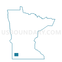
Mason Twp. Voting District, Murray County, Minnesota
About
Outline

Summary
| Unique Area Identifier | 603282 |
| Name | Mason Twp. Voting District |
| County | Murray County |
| State | Minnesota |
| Area (square miles) | 35.96 |
| Land Area (square miles) | 34.67 |
| Water Area (square miles) | 1.28 |
| % of Land Area | 96.43 |
| % of Water Area | 3.57 |
| Latitude of the Internal Point | 44.06110950 |
| Longtitude of the Internal Point | -95.75823890 |
Maps

Graphs
Select a template below for downloading or customizing gragh for Mason Twp. Voting District, Murray County, Minnesota


Neighbors
Neighoring Voting District (by Name) Neighboring Voting District on the Map
- Lake Sarah Twp. Voting District, Murray County, MN
- Leeds Twp. Voting District, Murray County, MN
- Lime Lake Twp. Voting District, Murray County, MN
- Lowville Twp. Voting District, Murray County, MN
- Murray Twp. Voting District, Murray County, MN
- Shetek Twp. Voting District, Murray County, MN
- Skandia Twp. Voting District, Murray County, MN
- Slayton Twp. Voting District, Murray County, MN
Top 10 Neighboring County Subdivision (by Population) Neighboring County Subdivision on the Map
- Lake Sarah township, Murray County, MN (393)
- Mason township, Murray County, MN (299)
- Shetek township, Murray County, MN (296)
- Slayton township, Murray County, MN (295)
- Leeds township, Murray County, MN (210)
- Lime Lake township, Murray County, MN (181)
- Murray township, Murray County, MN (177)
- Skandia township, Murray County, MN (172)
- Lowville township, Murray County, MN (169)
Top 10 Neighboring Place (by Population) Neighboring Place on the Map
Top 10 Neighboring Unified School District (by Population) Neighboring Unified School District on the Map
Top 10 Neighboring State Legislative District Lower Chamber (by Population) Neighboring State Legislative District Lower Chamber on the Map
Top 10 Neighboring State Legislative District Upper Chamber (by Population) Neighboring State Legislative District Upper Chamber on the Map
Top 10 Neighboring 111th Congressional District (by Population) Neighboring 111th Congressional District on the Map
Top 10 Neighboring Census Tract (by Population) Neighboring Census Tract on the Map
- Census Tract 9003, Murray County, MN (3,360)
- Census Tract 9002, Murray County, MN (3,246)
- Census Tract 9001, Murray County, MN (2,119)